
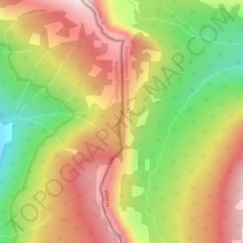
Topografische Karte South Kootenay Pass
Interaktive Karte
Klicken Sie auf die Karte, um die Höhe anzuzeigen.
Über diese Karte
Name: Topografische Karte South Kootenay Pass, Höhe, Relief.
Durchschnittliche Höhe: 2.007 m
Minimale Höhe: 1.658 m
Maximale Höhe: 2.321 m
Andere topografische Karten
Klicken Sie auf eine Karte, um ihre Topografie, ihre Höhe und ihr Relief anzuzeigen.
Mount Brett
Canada > Alberta > Division No. 15
Mount Brett, Division No. 15, Alberta, Canada
Durchschnittliche Höhe: 2.491 m
St. Isidore
Canada > Alberta > Division No. 17
St. Isidore, Division No. 17, Alberta, T0H 3B0, Canada
Durchschnittliche Höhe: 575 m
Village of Arrowwood
Canada > Alberta > Division No. 5
Village of Arrowwood, Division No. 5, Alberta, T0L 0A7, Canada
Durchschnittliche Höhe: 937 m
Sherwood Park
Canada > Alberta > Division No. 11
Sherwood Park, Division No. 11, Alberta, Canada
Durchschnittliche Höhe: 691 m
Fort McKay
Canada > Alberta > Division No. 16
Fort McKay, Division No. 16, Alberta, Canada
Durchschnittliche Höhe: 259 m
Okotoks
Canada > Alberta > Town of Okotoks
Okotoks, Town of Okotoks, Alberta, T1S 2N7, Canada
Durchschnittliche Höhe: 1.096 m
Stettler
Canada > Alberta > Division No. 7
Stettler, Division No. 7, Alberta, T0C 2L1, Canada
Durchschnittliche Höhe: 819 m
City of Wetaskiwin
Canada > Alberta > Division No. 11
City of Wetaskiwin, Division No. 11, Alberta, Canada
Durchschnittliche Höhe: 760 m
Picture Butte
Canada > Alberta > Division No. 2
Picture Butte, Division No. 2, Alberta, T0K 1V0, Canada
Durchschnittliche Höhe: 905 m
Lac La Biche County
Lac La Biche County, Alberta, Canada
Durchschnittliche Höhe: 624 m
Fort Saskachewan
Canada > Alberta > Division No. 11
Fort Saskachewan, Division No. 11, Alberta, Canada
Durchschnittliche Höhe: 637 m
Town of Crossfield
Town of Crossfield, Alberta, T0M 0S0, Canada
Durchschnittliche Höhe: 1.109 m
Clairmont
Canada > Alberta > Division No. 19 > Hamlet of Clairmont
Clairmont, Hamlet of Clairmont, Division No. 19, Alberta, T0H 0W0, Canada
Durchschnittliche Höhe: 679 m
City of Leduc
Canada > Alberta > Division No. 11
City of Leduc, Division No. 11, Alberta, Canada
Durchschnittliche Höhe: 727 m
Town of Slave Lake
Canada > Alberta > Municipal District of Lesser Slave River
Town of Slave Lake, Municipal District of Lesser Slave River, Alberta, Canada
Durchschnittliche Höhe: 589 m
Medicine Hat
Canada > Alberta > Division No. 1
Medicine Hat, Division No. 1, Alberta, Canada
Durchschnittliche Höhe: 708 m
Crowsnest Pass (municipality)
Crowsnest Pass (municipality), Alberta, T0K 0M0, Canada
Durchschnittliche Höhe: 1.537 m
Fort Macleod
Canada > Alberta > Division No. 3 > Fort Macleod
Fort Macleod, 26 Street, Fort Macleod, Division No. 3, Alberta, T0L 0Z0, Canada
Durchschnittliche Höhe: 946 m
City of Cold Lake
Canada > Alberta > Division No. 12
City of Cold Lake, Division No. 12, Alberta, Canada
Durchschnittliche Höhe: 542 m
Toronto Peak
Canada > Alberta > Division No. 15
Toronto Peak, Division No. 15, Alberta, Canada
Durchschnittliche Höhe: 2.423 m
Vermilion Lakes
Canada > Alberta > Improvement District No. 9 > Banff
Vermilion Lakes, Banff, Improvement District No. 9, Alberta, T1L 1E1, Canada
Durchschnittliche Höhe: 1.486 m
Athabasca Falls
Canada > Alberta > Improvement District No. 12
Athabasca Falls, Improvement District No. 12, Alberta, Canada
Durchschnittliche Höhe: 1.211 m
Chappelle
Canada > Alberta > Division No. 11
Chappelle, Heritage Valley, Division No. 11, Alberta, Canada
Durchschnittliche Höhe: 695 m
La Crete
Canada > Alberta > Mackenzie County
La Crete, Mackenzie County, Alberta, T0H 2H0, Canada
Durchschnittliche Höhe: 323 m