
Topografische Karte East Lindsey
Interaktive Karte
Klicken Sie auf die Karte, um die Höhe anzuzeigen.
Über diese Karte
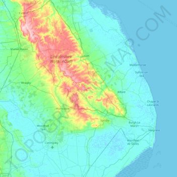
Name: Topografische Karte East Lindsey, Höhe, Relief.
Durchschnittliche Höhe: 24 m
Minimale Höhe: -1 m
Maximale Höhe: 169 m
Andere topografische Karten
Klicken Sie auf eine Karte, um ihre Topografie, ihre Höhe und ihr Relief anzuzeigen.
Three Kings Deer
United Kingdom > England > Lincolnshire > North Kesteven > Threekingham
Durchschnittliche Höhe: 24 m
Barholm
United Kingdom > England > Lincolnshire > South Kesteven > Greatford
Durchschnittliche Höhe: 17 m
Belleau Bridge
United Kingdom > England > Lincolnshire > East Lindsey > Aby > Belleau
Durchschnittliche Höhe: 30 m
Haverholme
United Kingdom > England > Lincolnshire > North Kesteven > Anwick
Durchschnittliche Höhe: 10 m
Eskham
United Kingdom > England > Lincolnshire > East Lindsey > Marshchapel
Durchschnittliche Höhe: 3 m
Scremby
United Kingdom > England > Lincolnshire > East Lindsey > Candlesby
Durchschnittliche Höhe: 32 m
Aisby
United Kingdom > England > Lincolnshire > West Lindsey > Corringham CP
Durchschnittliche Höhe: 20 m
Holbeach Clough
United Kingdom > England > Lincolnshire > South Holland > Holbeach CP > Saracen's Head
Durchschnittliche Höhe: 4 m
Cawkwell
United Kingdom > England > Lincolnshire > East Lindsey > Scamblesby
Durchschnittliche Höhe: 111 m
Scottlethorpe
United Kingdom > England > Lincolnshire > South Kesteven > Edenham
Durchschnittliche Höhe: 49 m
Louth Navigation
United Kingdom > England > Lincolnshire > East Lindsey > Alvingham
Durchschnittliche Höhe: 8 m
Caen Hill
United Kingdom > England > Lincolnshire > West Lindsey > Great Limber CP
Durchschnittliche Höhe: 83 m
Theddlethorpe St Helen
United Kingdom > England > Lincolnshire > East Lindsey
Durchschnittliche Höhe: 2 m
Willingham by Stow
United Kingdom > England > Lincolnshire > West Lindsey
Durchschnittliche Höhe: 15 m
Cowbridge Business Park
United Kingdom > England > Lincolnshire > East Lindsey
Durchschnittliche Höhe: 4 m
Saltfleetby St Peter
United Kingdom > England > Lincolnshire > East Lindsey
Durchschnittliche Höhe: 3 m
Halton Fenside
United Kingdom > England > Lincolnshire > East Lindsey > Little Steeping
Durchschnittliche Höhe: 8 m
Bishopbridge
United Kingdom > England > Lincolnshire > West Lindsey > Osgodby CP
Durchschnittliche Höhe: 10 m
Rase Park
United Kingdom > England > Lincolnshire > West Lindsey > Market Rasen
Durchschnittliche Höhe: 28 m
Cadwell Highfield
United Kingdom > England > Lincolnshire > East Lindsey
Durchschnittliche Höhe: 118 m
Spalding Marsh
United Kingdom > England > Lincolnshire > South Holland > Weston CP
Durchschnittliche Höhe: 4 m
Quarrington
United Kingdom > England > Lincolnshire > North Kesteven
According to the Köppen classification, the British Isles experience a maritime climate characterised by relatively cool summers and mild winters. Lincolnshire's position on the east of the Isles allows for a sunnier and warmer climate relative to the national average, and it is one of the driest counties in…
Durchschnittliche Höhe: 21 m
Wainfleet Haven
United Kingdom > England > Lincolnshire > East Lindsey > Wainfleet Clough
Durchschnittliche Höhe: 3 m
Kirkby la Thorpe
United Kingdom > England > Lincolnshire > North Kesteven
Durchschnittliche Höhe: 13 m
Sempringham
United Kingdom > England > Lincolnshire > South Kesteven > Pointon
Sempringham consists of a church and a holy well, with other houses east from the church scattered along the B1177 between Pointon and Billingborough. The church stands at an altitude of about 52 feet (16 m), on land rising out of flat fenland. Pointon is the chief township of the civil parish, which includes…
Durchschnittliche Höhe: 16 m
Low Fulney Estate
United Kingdom > England > Lincolnshire > South Holland > Spalding
Durchschnittliche Höhe: 4 m