
Topografische Karte East Lindsey
Interaktive Karte
Klicken Sie auf die Karte, um die Höhe anzuzeigen.
Über diese Karte
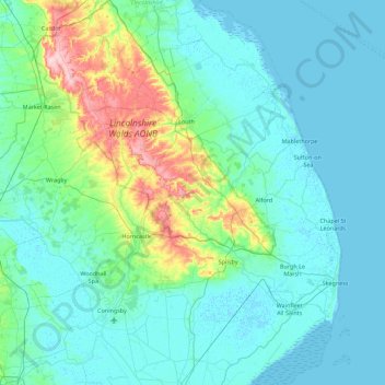
Name: Topografische Karte East Lindsey, Höhe, Relief.
Ort: East Lindsey, Lincolnshire, England, United Kingdom (53.00109 -0.31748 53.53488 0.35797)
Durchschnittliche Höhe: 24 m
Minimale Höhe: -1 m
Maximale Höhe: 169 m
Andere topografische Karten
Klicken Sie auf eine Karte, um ihre Topografie, ihre Höhe und ihr Relief anzuzeigen.
Scotland
United Kingdom > England > Lincolnshire > South Kesteven > Ingoldsby
Durchschnittliche Höhe: 77 m
Kingerby
United Kingdom > England > Lincolnshire > West Lindsey > Osgodby CP
Durchschnittliche Höhe: 16 m
Uffington Park
United Kingdom > England > Lincolnshire > South Kesteven > Uffington
Durchschnittliche Höhe: 30 m
Bowser's Corner
United Kingdom > England > Lincolnshire > East Lindsey > New Leake
Durchschnittliche Höhe: 1 m
Welton Cliff
United Kingdom > England > Lincolnshire > West Lindsey > Welton CP
Durchschnittliche Höhe: 53 m
Holbeach Marsh
United Kingdom > England > Lincolnshire > South Holland > Holbeach CP > Holbeach St Marks
Durchschnittliche Höhe: 4 m
Three Kings Deer
United Kingdom > England > Lincolnshire > North Kesteven > Threekingham
Durchschnittliche Höhe: 24 m
Barholm
United Kingdom > England > Lincolnshire > South Kesteven > Greatford
Durchschnittliche Höhe: 17 m
Belleau Bridge
United Kingdom > England > Lincolnshire > East Lindsey > Aby > Belleau
Durchschnittliche Höhe: 30 m
Haverholme
United Kingdom > England > Lincolnshire > North Kesteven > Anwick
Durchschnittliche Höhe: 10 m
Eskham
United Kingdom > England > Lincolnshire > East Lindsey > Marshchapel
Durchschnittliche Höhe: 3 m
Scremby
United Kingdom > England > Lincolnshire > East Lindsey > Candlesby
Durchschnittliche Höhe: 32 m
Aisby
United Kingdom > England > Lincolnshire > West Lindsey > Corringham CP
Durchschnittliche Höhe: 20 m
Holbeach Clough
United Kingdom > England > Lincolnshire > South Holland > Holbeach CP > Saracen's Head
Durchschnittliche Höhe: 4 m
Cawkwell
United Kingdom > England > Lincolnshire > East Lindsey > Scamblesby
Durchschnittliche Höhe: 111 m
Scottlethorpe
United Kingdom > England > Lincolnshire > South Kesteven > Edenham
Durchschnittliche Höhe: 49 m
Louth Navigation
United Kingdom > England > Lincolnshire > East Lindsey > Alvingham
Durchschnittliche Höhe: 8 m
Caen Hill
United Kingdom > England > Lincolnshire > West Lindsey > Great Limber CP
Durchschnittliche Höhe: 83 m
Theddlethorpe St Helen
United Kingdom > England > Lincolnshire > East Lindsey
Durchschnittliche Höhe: 2 m
Willingham by Stow
United Kingdom > England > Lincolnshire > West Lindsey
Durchschnittliche Höhe: 15 m
Cowbridge Business Park
United Kingdom > England > Lincolnshire > East Lindsey
Durchschnittliche Höhe: 4 m
Saltfleetby St Peter
United Kingdom > England > Lincolnshire > East Lindsey
Durchschnittliche Höhe: 3 m
Halton Fenside
United Kingdom > England > Lincolnshire > East Lindsey > Little Steeping
Durchschnittliche Höhe: 8 m
Bishopbridge
United Kingdom > England > Lincolnshire > West Lindsey > Osgodby CP
Durchschnittliche Höhe: 10 m
Rase Park
United Kingdom > England > Lincolnshire > West Lindsey > Market Rasen
Durchschnittliche Höhe: 28 m
Cadwell Highfield
United Kingdom > England > Lincolnshire > East Lindsey
Durchschnittliche Höhe: 118 m