
Topografische Karte Silves
Interaktive Karte
Klicken Sie auf die Karte, um die Höhe anzuzeigen.
Silves
Metallgegenstände aus dieser Phase waren in ganz Südportugal bis in die 80er Jahre selten, doch gerade in Silves und in Mértola fanden sich zahlreiche Werkzeuge, Schmuck, aber auch chirurgische Instrumente, wie Zangen, Nadeln, Skalpelle. Die Glasproduktion aus der römischen Zeit war nie abgerissen, doch wurde sie seltener und die filigranen Produkte waren nur den höheren Schichten zugänglich. Dabei zeigten sich technische Kontinuitäten, die bis in die Bronzezeit zurückreichen.
Über diese Karte
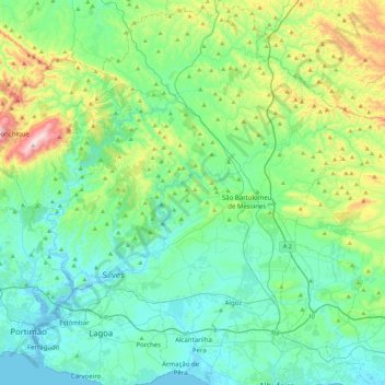
Name: Topografische Karte Silves, Höhe, Relief.
Ort: Silves, Faro, Portugal (37.08862 -8.53546 37.43939 -8.17688)
Durchschnittliche Höhe: 158 m
Minimale Höhe: -5 m
Maximale Höhe: 754 m
Andere topografische Karten
Klicken Sie auf eine Karte, um ihre Topografie, ihre Höhe und ihr Relief anzuzeigen.
Cerro do Leiria
Portugal > Faro > Santa Catarina da Fonte do Bispo > Santa Catarina da Fonte do Bispo > Cerro do Leiria
Durchschnittliche Höhe: 156 m
Caldas de Monchique
Portugal > Faro > Caldas de Monchique > Caldas de Monchique
Durchschnittliche Höhe: 300 m