
Topografische Karte Bhubaneshwar
Interaktive Karte
Klicken Sie auf die Karte, um die Höhe anzuzeigen.
Über diese Karte
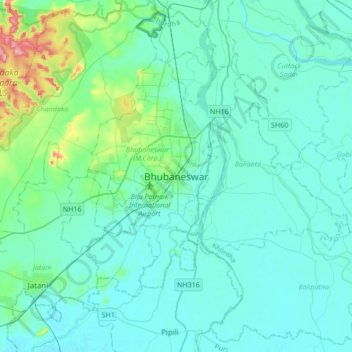
Name: Topografische Karte Bhubaneshwar, Höhe, Relief.
Durchschnittliche Höhe: 30 m
Minimale Höhe: 6 m
Maximale Höhe: 199 m
Bhubaneswar is in Khordha district of Odisha. It is in the eastern coastal plains, along the axis of the Eastern Ghats mountains. The city has an average altitude of 45 m (148 ft) above sea level. It lies southwest of the Mahanadi River that forms the northern boundary of Bhubaneswar metropolitan area, within its delta.
Andere topografische Karten
Klicken Sie auf eine Karte, um ihre Topografie, ihre Höhe und ihr Relief anzuzeigen.
Bhubaneswar Municipal Corporation
India > Odisha > Bhubaneswar (M.Corp.)
Bhubaneswar Municipal Corporation, Bhubaneswar (M.Corp.), Khordha, Odisha, India
Durchschnittliche Höhe: 37 m
Vani Vihar
India > Odisha > Bhubaneswar (M.Corp.) > Bhubaneswar Municipal Corporation
Vani Vihar, Bhubaneswar Municipal Corporation, Bhubaneswar (M.Corp.), Khordha, Odisha, India
Durchschnittliche Höhe: 40 m
Ward 16
India > Odisha > Bhubaneswar (M.Corp.) > Bhubaneswar Municipal Corporation
Ward 16, North Zone, Bhubaneswar Municipal Corporation, Bhubaneswar (M.Corp.), Khordha, Odisha, India
Durchschnittliche Höhe: 57 m
Ward 30
India > Odisha > Bhubaneswar (M.Corp.) > Bhubaneswar Municipal Corporation
Ward 30, Saheed Nagar, Bhubaneswar Municipal Corporation, Bhubaneswar (M.Corp.), Khordha, Odisha, 751007, India
Durchschnittliche Höhe: 36 m