
Topografische Karte Sunday Lake
Interaktive Karte
Klicken Sie auf die Karte, um die Höhe anzuzeigen.
Über diese Karte
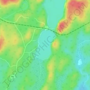
Name: Topografische Karte Sunday Lake, Höhe, Relief.
Durchschnittliche Höhe: 399 m
Minimale Höhe: 374 m
Maximale Höhe: 437 m
Andere topografische Karten
Klicken Sie auf eine Karte, um ihre Topografie, ihre Höhe und ihr Relief anzuzeigen.
Anishinabi Lake
Canada > Ontario > Unorganized Kenora District
Anishinabi Lake, Unorganized Kenora District, Kenora District, Ontario, Canada
Durchschnittliche Höhe: 374 m
White Otter Lake
Canada > Ontario > Unorganized Kenora District
White Otter Lake, Unorganized Kenora District, Kenora District, Ontario, Canada
Durchschnittliche Höhe: 439 m
Opasquia Provincial Park
Canada > Ontario > Unorganized Kenora District
Opasquia Provincial Park, Unorganized Kenora District, Kenora District, Ontario, Canada
Durchschnittliche Höhe: 282 m