
Topografische Karte Fernandina Beach
Interaktive Karte
Klicken Sie auf die Karte, um die Höhe anzuzeigen.
Über diese Karte
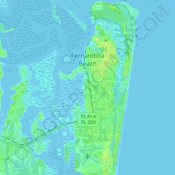
Name: Topografische Karte Fernandina Beach, Höhe, Relief.
Durchschnittliche Höhe: 2 m
Minimale Höhe: -4 m
Maximale Höhe: 17 m
Andere topografische Karten
Klicken Sie auf eine Karte, um ihre Topografie, ihre Höhe und ihr Relief anzuzeigen.
Amelia Island
United States > Florida > Nassau County > Fernandina Beach
Amelia Island, Fernandina Beach, Nassau County, Florida, 32034, United States
Durchschnittliche Höhe: 3 m
Kings Ferry
United States > Florida > Nassau County
Kings Ferry, Nassau County, Florida, United States
Durchschnittliche Höhe: 4 m
Chester
United States > Florida > Nassau County
Chester, Nassau County, Florida, United States
Durchschnittliche Höhe: 4 m
Yulee
United States > Florida > Nassau County > Yulee
Yulee, Nassau County, Florida, United States
Durchschnittliche Höhe: 6 m
Hilliard
United States > Florida > Nassau County
Hilliard, Nassau County, Florida, 32046, United States
Durchschnittliche Höhe: 21 m
Callahan
United States > Florida > Nassau County
Callahan, Nassau County, Florida, 32011, United States
Durchschnittliche Höhe: 6 m