
Spenden
Rüsten Sie sich für Ihr nächstes Abenteuer:
Als Amazon-Partner erhält diese Website eine Provision für qualifizierte Käufe, ohne zusätzliche Kosten für Sie.
Topografische Karte Kedarnath
Klicken Sie auf die Karte, um die Höhe anzuzeigen.
Spenden
Rüsten Sie sich für Ihr nächstes Abenteuer:
Als Amazon-Partner erhält diese Website eine Provision für qualifizierte Käufe, ohne zusätzliche Kosten für Sie.
Kedarnath
Ort und Tempel von Kedarnath liegen in den südlichen Ausläufern des Himalaya-Gebirges in einer Höhe von ca. 3500 bzw. 3600 m ü. d. M. nahe der Quelle des Mandakini-Flusses. Das ca. 15 km lange letzte Teilstück vom knapp 2000 m hoch gelegenen Ort Gaurikund nach Kedarnath ist nur mittels eines Helikopter-Services, auf dem Rücken von Maultieren oder zu Fuß zu bewältigen. Die nächsten größeren Städte sind Rishikesh oder Haridwar (jeweils ca. 250 km Fahrtstrecke südwestlich). Das Klima ist kühl, doch können die Tagestemperaturen im Sommer durchaus 20 bis 25 °C erreichen; Regen fällt hauptsächlich in den Monsunmonaten von Mitte Juni bis Mitte Oktober.
Spenden
Rüsten Sie sich für Ihr nächstes Abenteuer:
Als Amazon-Partner erhält diese Website eine Provision für qualifizierte Käufe, ohne zusätzliche Kosten für Sie.
Über diese Karte
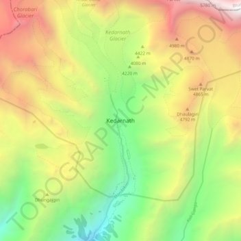
Name: Topografische Karte Kedarnath, Höhe, Relief.
Ort: Kedarnath, Ukhimath, Rudraprayag, Uttarakhand, Indien (30.69456 79.02732 30.77456 79.10732)
Durchschnittliche Höhe: 4.219 m
Minimale Höhe: 2.761 m
Maximale Höhe: 6.050 m
Spenden
Rüsten Sie sich für Ihr nächstes Abenteuer:
Als Amazon-Partner erhält diese Website eine Provision für qualifizierte Käufe, ohne zusätzliche Kosten für Sie.