
Topografische Karte Cumberland Gap
Interaktive Karte
Klicken Sie auf die Karte, um die Höhe anzuzeigen.
Cumberland Gap
Cumberland Gap ist der Name eines auf 488 Meter Höhe gelegenen Gebirgspasses in den Cumberland Mountains, einer Bergkette der Appalachen. Berühmt wurde er im 18. und 19. Jahrhundert als Hauptweg der weißen Siedler ins Landesinnere Nordamerikas. Der Pass war Teil der Wilderness Road, einem ehemaligen Indianerpfad, den Daniel Boone mit 35 Männern erweiterte.
Über diese Karte
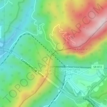
Name: Topografische Karte Cumberland Gap, Höhe, Relief.
Durchschnittliche Höhe: 512 m
Minimale Höhe: 349 m
Maximale Höhe: 783 m