
Topografische Karte Medel (Lucmagn)
Interaktive Karte
Klicken Sie auf die Karte, um die Höhe anzuzeigen.
Medel (Lucmagn)
Als niedrigster alpenquerender Pass der Schweiz wurde der Lukmanier bis ins Spätmittelalter stark begangen. In Hospizen in Sogn Gions, Sogn Gagl und Santa Maria unterhalb der Passhöhe fanden die Reisenden Schutz. 1872 wurde eine moderne Strasse bis Platta durch die Schlucht am Talausgang eröffnet, die den alten Saumpfad über Mumpé Medel ersetzte. Nach Fertigstellung der Passstrasse fuhren von 1878 bis 1910 Postkutschen über den Lukmanier.
Über diese Karte
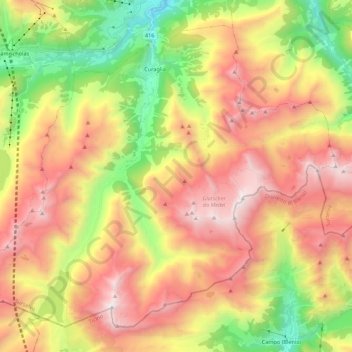
Name: Topografische Karte Medel (Lucmagn), Höhe, Relief.
Ort: Medel (Lucmagn), Surselva, Graubünden, Schweiz (46.56313 8.75041 46.69194 8.96910)
Durchschnittliche Höhe: 2.100 m
Minimale Höhe: 1.041 m
Maximale Höhe: 3.179 m
Andere topografische Karten
Klicken Sie auf eine Karte, um ihre Topografie, ihre Höhe und ihr Relief anzuzeigen.
Surrein (Tujetsch)
Schweiz > Graubünden > Surselva > Tujetsch > Sedrun
Durchschnittliche Höhe: 1.642 m
Obersaxen Tusa
Schweiz > Graubünden > Surselva > Obersaxen-Mundaun > Meierhof
Durchschnittliche Höhe: 1.244 m
Obersaxen Giraniga
Schweiz > Graubünden > Surselva > Obersaxen-Mundaun
Durchschnittliche Höhe: 1.271 m
Panix
Schweiz > Graubünden > Surselva > Ilanz/Glion
Der Fernwanderweg Senda Sursilvana führt als touristisch markierter Höhenweg von Breil/Brigels-Waltensburg/Vuorz-Andiast durch Panix und weiter entlang des jungen Rheins in Richtung Chur.
Durchschnittliche Höhe: 1.634 m
Gliarauns
Schweiz > Graubünden > Surselva > Medel (Lucmagn) > Curaglia
Durchschnittliche Höhe: 1.675 m
Seth
Schweiz > Graubünden > Surselva > Ilanz/Glion
Das Haufendorf liegt auf einer Terrasse hoch über dem linken Ufer des Vorderrheins. Die Gemeinde reicht von 930 m ü. M. nördlich von Rueun und Schnaus bis auf eine Höhe von 2833 m in der Nähe des Vorab an der Grenze zum Kanton Glarus. Vom gesamten Gemeindegebiet von 1348 ha sind 689 ha landwirtschaftlich…
Durchschnittliche Höhe: 1.275 m
Obersaxen-Misanenga
Schweiz > Graubünden > Surselva > Obersaxen-Mundaun
Durchschnittliche Höhe: 1.336 m