
Spenden
Rüsten Sie sich für Ihr nächstes Abenteuer:
Als Amazon-Partner erhält diese Website eine Provision für qualifizierte Käufe, ohne zusätzliche Kosten für Sie.
Topografische Karte Quebec
Klicken Sie auf die Karte, um die Höhe anzuzeigen.
Spenden
Rüsten Sie sich für Ihr nächstes Abenteuer:
Als Amazon-Partner erhält diese Website eine Provision für qualifizierte Käufe, ohne zusätzliche Kosten für Sie.
Quebec
Québec liegt am Nordufer des Sankt-Lorenz-Stroms, dem drittgrößten Fluss Nordamerikas (gemessen an der Abflussmenge). Der Strom ist oberhalb der Stadt zweieinhalb bis drei Kilometer breit und verengt sich im Bereich des Stadtzentrums auf etwas mehr als einen Kilometer. Anschließend teilt er sich in zwei Arme, welche die Île d’Orléans umgeben. Nach dieser Insel beginnt der über 350 km lange und bis zu 60 km breite Sankt-Lorenz-Ästuar. Da die Rinne die Fließgeschwindigkeit stark erhöht und die Gezeiten aufgrund des geringen Höhenunterschieds zum Atlantischen Ozean noch deutlich spürbar sind (1,8 bis 3,1 m Unterschied zwischen Ebbe und Flut), ist der Engpass von Québec eine für die Schifffahrt anspruchsvolle Stelle.
Spenden
Rüsten Sie sich für Ihr nächstes Abenteuer:
Als Amazon-Partner erhält diese Website eine Provision für qualifizierte Käufe, ohne zusätzliche Kosten für Sie.
Über diese Karte
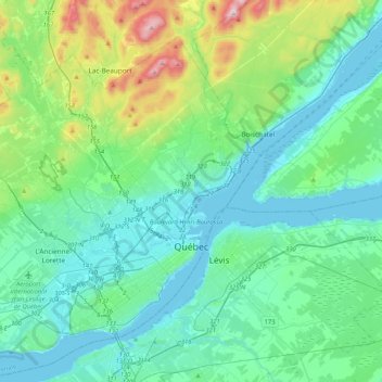
Name: Topografische Karte Quebec, Höhe, Relief.
Durchschnittliche Höhe: 117 m
Minimale Höhe: -3 m
Maximale Höhe: 629 m
Spenden
Rüsten Sie sich für Ihr nächstes Abenteuer:
Als Amazon-Partner erhält diese Website eine Provision für qualifizierte Käufe, ohne zusätzliche Kosten für Sie.