Geolokalisieren
👉 Easily get elevation data in JSON, GeoTIFF and KML formats using Elevation API
Vielen Dank für die Unterstützung dieser Website ❤️
Spenden

Topografische Karte Mount Temple

Klicken Sie auf die Karte, um die Höhe anzuzeigen.

👉 Easily get elevation data in JSON, GeoTIFF and KML formats using Elevation API
Vielen Dank für die Unterstützung dieser Website ❤️
Spenden

Rüsten Sie sich für Ihr nächstes Abenteuer:

Als Amazon-Partner erhält diese Website eine Provision für qualifizierte Käufe, ohne zusätzliche Kosten für Sie.

Über diese Karte

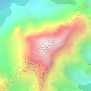
Name: Topografische Karte Mount Temple, Höhe, Relief.

Ort: Mount Temple, Improvement District No. 9, Alberta, Canada (51.35104 -116.20658 51.35114 -116.20648)

Durchschnittliche Höhe: 2.644 m

Minimale Höhe: 1.941 m

Maximale Höhe: 3.522 m

Andere topografische Karten

Klicken Sie auf eine Karte, um ihre Topografie, ihre Höhe und ihr Relief anzuzeigen.

Mistaya Lake

Canada > Alberta > Improvement District No. 9

Durchschnittliche Höhe: 1.849 m

Bow Glacier

Canada > Alberta > Improvement District No. 9

Durchschnittliche Höhe: 2.556 m

Saskatchewan Glacier

Canada > Alberta > Improvement District No. 9

Durchschnittliche Höhe: 2.482 m

Crowfoot Glacier

Canada > Alberta > Improvement District No. 9

Durchschnittliche Höhe: 2.565 m

Marvel Lake

Canada > Alberta > Improvement District No. 9

Durchschnittliche Höhe: 2.091 m

Moraine Lake

Canada > Alberta > Improvement District No. 9

Moraine Lake is a snow and glacially fed alpine lake in Banff National Park, 14 kilometres (8.7 mi) outside the village of Lake Louise, Alberta, Canada. It is situated in the Valley of the Ten Peaks, at an elevation of approximately 1,884 metres (6,181 ft). The lake has a surface area of 50 hectares (120…

Durchschnittliche Höhe: 2.101 m

Johnston Canyon

Canada > Alberta > Improvement District No. 9

Durchschnittliche Höhe: 1.554 m

40 Mile Creek

Canada > Alberta > Improvement District No. 9

Durchschnittliche Höhe: 1.458 m

Lake Minnewanka

Canada > Alberta > Improvement District No. 9

Durchschnittliche Höhe: 1.935 m

Peyto Lake

Canada > Alberta > Improvement District No. 9

Durchschnittliche Höhe: 1.996 m

Shadow Lake

Canada > Alberta > Improvement District No. 9

Durchschnittliche Höhe: 2.014 m

Vielen Dank für die Unterstützung dieser Website ❤️
Spenden

Rüsten Sie sich für Ihr nächstes Abenteuer:

Als Amazon-Partner erhält diese Website eine Provision für qualifizierte Käufe, ohne zusätzliche Kosten für Sie.

Bow River

Canada > Alberta > Improvement District No. 9 > Banff

Durchschnittliche Höhe: 1.462 m

Hector Lake

Canada > Alberta > Improvement District No. 9

Durchschnittliche Höhe: 1.925 m

Lake Minnewanka

Canada > Alberta > Improvement District No. 9

Durchschnittliche Höhe: 1.935 m

Lake Agnes

Canada > Alberta > Improvement District No. 9

Durchschnittliche Höhe: 2.157 m

Moraine Lake

Canada > Alberta > Improvement District No. 9

Moraine Lake is a snow and glacially fed alpine lake in Banff National Park, 14 kilometres (8.7 mi) outside the village of Lake Louise, Alberta, Canada. It is situated in the Valley of the Ten Peaks, at an elevation of approximately 1,884 metres (6,181 ft). The lake has a surface area of 50 hectares (120…

Durchschnittliche Höhe: 2.101 m

Johnston Creek

Canada > Alberta > Improvement District No. 9

Johnston Creek originates north of Castle Mountain in a glacial valley southwest of Badger Pass and south of Pulsatilla Pass, at an elevation of 2,500 meters (8,200 ft). The creek flows southeast between Helena Ridge and the Sawback Range, and then south through a gorge known as Johnston Canyon. The stream…

Durchschnittliche Höhe: 2.135 m

Hector Lake

Canada > Alberta > Improvement District No. 9

Durchschnittliche Höhe: 1.925 m

Bow Lake

Canada > Alberta > Improvement District No. 9

Durchschnittliche Höhe: 2.167 m

Arnica Lake

Canada > Alberta > Improvement District No. 9

Durchschnittliche Höhe: 2.245 m

Arnica Lake

Canada > Alberta > Improvement District No. 9

Durchschnittliche Höhe: 2.290 m

Rüsten Sie sich für Ihr nächstes Abenteuer:

🦟Insektenschutzmittel - Effektive Abwehr von Zecken und Mücken im Wald
🔭Leichte Reisestative - Stabile Basis für Fotos und Spektive bei geringem Gewicht
🎒Wanderrucksäcke - Ergonomische Rucksäcke für Tages- und Mehrtagestouren
💧Tragbare Wasserfilter - Sicheres Trinkwasser aus Bächen und Seen
📍Verstellbare Wanderstöcke - Leichte und stabile Trekkingstöcke

Als Amazon-Partner erhält diese Website eine Provision für qualifizierte Käufe, ohne zusätzliche Kosten für Sie.