
Spenden
Rüsten Sie sich für Ihr nächstes Abenteuer:
Als Amazon-Partner erhält diese Website eine Provision für qualifizierte Käufe, ohne zusätzliche Kosten für Sie.
Topografische Karte Eibar
Klicken Sie auf die Karte, um die Höhe anzuzeigen.
Spenden
Rüsten Sie sich für Ihr nächstes Abenteuer:
Als Amazon-Partner erhält diese Website eine Provision für qualifizierte Käufe, ohne zusätzliche Kosten für Sie.
Eibar
Eibar befindet sich auf 121 m Höhe im Deba-Becken im äußersten Westen der Provinz Gipuzkoa an der Grenze zu Bizkaia. Das Klima ist maritim mit milden Wintern und kühlen Sommern. Die Stadt befindet sich in einem schmalen Tal in bergiger Umgebung, die Erhebungen rings um die Stadt weisen Höhen von 700 bis 800 m auf.
Spenden
Rüsten Sie sich für Ihr nächstes Abenteuer:
Als Amazon-Partner erhält diese Website eine Provision für qualifizierte Käufe, ohne zusätzliche Kosten für Sie.
Über diese Karte
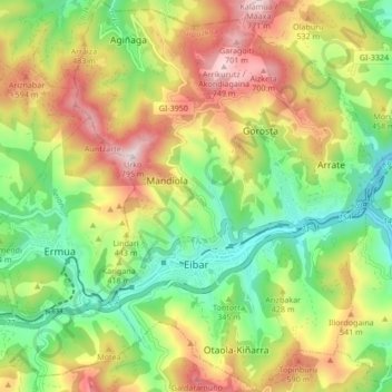
Name: Topografische Karte Eibar, Höhe, Relief.
Durchschnittliche Höhe: 367 m
Minimale Höhe: 74 m
Maximale Höhe: 768 m
Spenden
Rüsten Sie sich für Ihr nächstes Abenteuer:
Als Amazon-Partner erhält diese Website eine Provision für qualifizierte Käufe, ohne zusätzliche Kosten für Sie.