Geolokalisieren

Topografische Karte Grimselpass

Interaktive Karte

Klicken Sie auf die Karte, um die Höhe anzuzeigen.

Über diese Karte

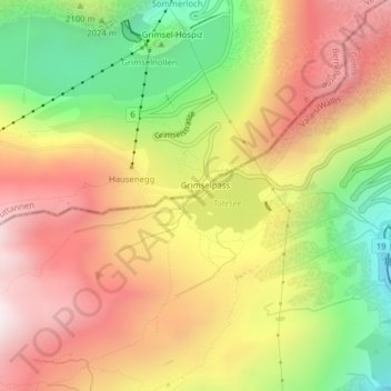
Name: Topografische Karte Grimselpass, Höhe, Relief.

Ort: Grimselpass, Obergoms, Goms, Wallis, 3999, Switzerland (46.56113 8.33663 46.56123 8.33673)

Durchschnittliche Höhe: 2.154 m

Minimale Höhe: 1.650 m

Maximale Höhe: 2.596 m

The Grimsel Pass (German: Grimselpass; French: Col du Grimsel; Italian: Passo del Grimsel) is a mountain pass in Switzerland, crossing the Bernese Alps at an elevation of 2,164 metres (7,100 ft). The pass connects the Haslital, the upper valley of the river Aare, with the upper valley of the Rhône. In so doing, and as the Aare is a tributary of the Rhine, the pass crosses the continental divide between the North Sea and the Mediterranean Sea.

Wikipedia (CC-BY-SA 3.0)

Andere topografische Karten

Klicken Sie auf eine Karte, um ihre Topografie, ihre Höhe und ihr Relief anzuzeigen.

Rhonegletscher

Switzerland > Wallis > Goms > Obergoms

Rhonegletscher, Obergoms, Goms, Oberland administrative region, Wallis, Switzerland

Durchschnittliche Höhe: 2.805 m