
Spenden
Rüsten Sie sich für Ihr nächstes Abenteuer:
Als Amazon-Partner erhält diese Website eine Provision für qualifizierte Käufe, ohne zusätzliche Kosten für Sie.
Topografische Karte La Morra
Klicken Sie auf die Karte, um die Höhe anzuzeigen.
Spenden
Rüsten Sie sich für Ihr nächstes Abenteuer:
Als Amazon-Partner erhält diese Website eine Provision für qualifizierte Käufe, ohne zusätzliche Kosten für Sie.
La Morra
Torre La Morra, erbaut 1709–1711, Gesamthöhe 31 Meter
Spenden
Rüsten Sie sich für Ihr nächstes Abenteuer:
Als Amazon-Partner erhält diese Website eine Provision für qualifizierte Käufe, ohne zusätzliche Kosten für Sie.
Über diese Karte
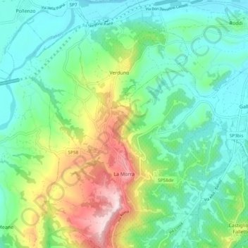
Name: Topografische Karte La Morra, Höhe, Relief.
Ort: La Morra, Cuneo, Piemont, 12064, Italien (44.61824 7.89512 44.68575 7.97393)
Durchschnittliche Höhe: 281 m
Minimale Höhe: 173 m
Maximale Höhe: 546 m
Spenden
Rüsten Sie sich für Ihr nächstes Abenteuer:
Als Amazon-Partner erhält diese Website eine Provision für qualifizierte Käufe, ohne zusätzliche Kosten für Sie.
Andere topografische Karten
Klicken Sie auf eine Karte, um ihre Topografie, ihre Höhe und ihr Relief anzuzeigen.
Spenden
Rüsten Sie sich für Ihr nächstes Abenteuer:
Als Amazon-Partner erhält diese Website eine Provision für qualifizierte Käufe, ohne zusätzliche Kosten für Sie.
Spenden
Rüsten Sie sich für Ihr nächstes Abenteuer:
Als Amazon-Partner erhält diese Website eine Provision für qualifizierte Käufe, ohne zusätzliche Kosten für Sie.
Col Agnel / Colle dell'Agnello
Italien > Piemont > Cuneo > Pontechianale
Durchschnittliche Höhe: 2.700 m
Monviso
Italien > Piemont > Cuneo > Pontechianale
Den Normalweg, der über die Südseite auf den Gipfel führt, erreicht man von Osten (Italien) vom Ausgangsort Crissolo im oberen Po-Tal über die Hütten Pian del Re und Quintino Sella am See Lago Grande di Viso (2640 m). Von Westen (Frankreich) erreicht man den Normalweg über die Hütte Rifugio Vallanta.…
Durchschnittliche Höhe: 2.985 m
Spenden
Rüsten Sie sich für Ihr nächstes Abenteuer:
Als Amazon-Partner erhält diese Website eine Provision für qualifizierte Käufe, ohne zusätzliche Kosten für Sie.