Geolokalisieren

Topografische Karte Patras

Interaktive Karte

Klicken Sie auf die Karte, um die Höhe anzuzeigen.

Über diese Karte

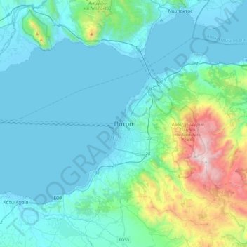
Name: Topografische Karte Patras, Höhe, Relief.

Ort: Patras, Municipal Unit of Patras, Municipality of Patras, Achaia Regional Unit, Western Greece, Peloponnese, Western Greece and the Ionian, 262 21, Greece (38.08624 21.57508 38.40624 21.89508)

Durchschnittliche Höhe: 283 m

Minimale Höhe: -5 m

Maximale Höhe: 1.918 m

A central feature of the urban geography of Patras is its division into upper and lower sections. This is the result of an interplay between natural geography and human settlement patterns; the lower section of the city (Kato Poli), which includes the 19th-century urban core and the port, is adjacent to the sea and stretches between the estuaries of the rivers of Glafkos and Haradros. It is built on what was originally a bed of river soils and dried-up swamps. The older upper section (Ano Poli) covers the area of the pre-modern settlement, around the Fortress, on what is the last elevation of Mount Panachaikon (1,926 m (6,319 ft)) before the Gulf of Patras.

Wikipedia (CC-BY-SA 3.0)

Andere topografische Karten

Klicken Sie auf eine Karte, um ihre Topografie, ihre Höhe und ihr Relief anzuzeigen.

Aigio

Greece > Peloponnese, Western Greece and the Ionian > Achaia Regional Unit

Aigio, Municipal Unit of Aegio, Municipality of Aigialeia, Achaia Regional Unit, Western Greece, Peloponnese, Western Greece and the Ionian, 251 00, Greece

Durchschnittliche Höhe: 371 m

Municipality of Patras

Greece > Peloponnese, Western Greece and the Ionian > Achaia Regional Unit

Municipality of Patras, Achaia Regional Unit, Western Greece, Peloponnese, Western Greece and the Ionian, Greece

Durchschnittliche Höhe: 291 m