
Topografische Karte East Greenbush CDP
Interaktive Karte
Klicken Sie auf die Karte, um die Höhe anzuzeigen.
East Greenbush CDP
The western section of the town along the Hudson River is marked by bluffs that rise to an elevation of between 100 and 300 feet. The little flat land that exists along the river is on the Papscanee Island. Papscanee Island is actually a peninsula, separated from the rest of the town by the Papscanee Creek. The town then spreads out as rolling hills rising towards the east. Mill Creek (formerly Tierken Kill) and Morden Creek are the principal streams of the town.
Über diese Karte
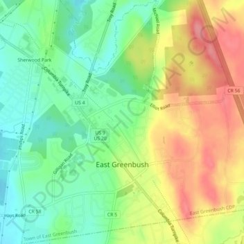
Name: Topografische Karte East Greenbush CDP, Höhe, Relief.
Durchschnittliche Höhe: 96 m
Minimale Höhe: 49 m
Maximale Höhe: 171 m