
Spenden
Rüsten Sie sich für Ihr nächstes Abenteuer:
Als Amazon-Partner erhält diese Website eine Provision für qualifizierte Käufe, ohne zusätzliche Kosten für Sie.
Topografische Karte Meghalaya
Klicken Sie auf die Karte, um die Höhe anzuzeigen.
Spenden
Rüsten Sie sich für Ihr nächstes Abenteuer:
Als Amazon-Partner erhält diese Website eine Provision für qualifizierte Käufe, ohne zusätzliche Kosten für Sie.
Meghalaya
Meghalaya ist ein indischer Bundesstaat mit einer Fläche von 22.429 km² und knapp 3 Millionen Einwohnern (Volkszählung 2011). Die Hauptstadt Meghalayas ist Shillong (auf 1500 m Höhe, 143.000 Einwohner), die Hauptsprachen sind Khasi und Garo; neben diesen dient Englisch als weitere Amtssprache. Der Name „Meghalaya“ wurde neu gebildet aus Sanskrit und bedeutet „Heimstätte der Wolken“ (in Hindi मेघालय meghālaya).
Spenden
Rüsten Sie sich für Ihr nächstes Abenteuer:
Als Amazon-Partner erhält diese Website eine Provision für qualifizierte Käufe, ohne zusätzliche Kosten für Sie.
Über diese Karte
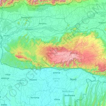
Name: Topografische Karte Meghalaya, Höhe, Relief.
Ort: Meghalaya, Indien (25.03065 89.81444 26.11817 92.80274)
Durchschnittliche Höhe: 244 m
Minimale Höhe: 0 m
Maximale Höhe: 2.336 m
Spenden
Rüsten Sie sich für Ihr nächstes Abenteuer:
Als Amazon-Partner erhält diese Website eine Provision für qualifizierte Käufe, ohne zusätzliche Kosten für Sie.
Andere topografische Karten
Klicken Sie auf eine Karte, um ihre Topografie, ihre Höhe und ihr Relief anzuzeigen.
Dharamsala
Indien > Himachal Pradesh > Dharamshala
Dharamsala ist aufgeteilt in das wirtschaftliche Zentrum Lower Dharamsala (auch Kotwali Bazaar u. a., 1280 m) und das ca. 5 km (Luftlinie), aber ca. 15 km Fahrtstrecke nördlich gelegene Pilgerzentrum Upper Dharamsala (auch McLeod Ganj, 1830 m). Aufgrund der Höhendifferenz liegen beide Ortsteile getrennt.…
Durchschnittliche Höhe: 1.781 m
Spenden
Rüsten Sie sich für Ihr nächstes Abenteuer:
Als Amazon-Partner erhält diese Website eine Provision für qualifizierte Käufe, ohne zusätzliche Kosten für Sie.
Puducherry
Indien > Puducherry > Puducherry Taluk
Puducherry liegt im Süden Indiens rund 135 Kilometer südlich von Chennai an der Koromandelküste am Golf von Bengalen. Die nächstgelegenen Städte sind Cuddalore ca. 20 Kilometer südlich und Viluppuram ca. 35 Kilometer landeinwärts. Puducherry liegt auf Meereshöhe im flachen Schwemmland der Küstenebene.…
Durchschnittliche Höhe: 10 m
Sinnar
Indien > Maharashtra > Sinnar
Sinnar liegt auf dem Dekkan-Plateau etwa 30 km südöstlich der Stadt Nashik in einer Höhe von etwa 650 m. Die Millionenstadt Mumbai ist etwa 185 km in südwestlicher Richtung entfernt. Das Klima ist warm bis heiß; Regen (ca. 705 mm/Jahr) fällt ganz überwiegend in den sommerlichen Monsunmonaten.
Durchschnittliche Höhe: 684 m
Munnar
Munnar liegt am Zusammenfluss der Flüsse Muthirappuzha, Nallathanni und Kundaly auf einer Höhe von ca. 1500 bis 1600 Metern. Der Name Munnar wurde daher wahrscheinlich aus den Malayalam-Wörtern munu („drei“) und aru („Fluss“) abgeleitet.
Durchschnittliche Höhe: 1.603 m
Spenden
Rüsten Sie sich für Ihr nächstes Abenteuer:
Als Amazon-Partner erhält diese Website eine Provision für qualifizierte Käufe, ohne zusätzliche Kosten für Sie.
Spenden
Rüsten Sie sich für Ihr nächstes Abenteuer:
Als Amazon-Partner erhält diese Website eine Provision für qualifizierte Käufe, ohne zusätzliche Kosten für Sie.
Spenden
Rüsten Sie sich für Ihr nächstes Abenteuer:
Als Amazon-Partner erhält diese Website eine Provision für qualifizierte Käufe, ohne zusätzliche Kosten für Sie.