Geolokalisieren

Topografische Karte Nashik

Klicken Sie auf die Karte, um die Höhe anzuzeigen.

👉 Easily get elevation data in JSON, GeoTIFF and KML formats using Elevation API
Vielen Dank für die Unterstützung dieser Website ❤️
Spenden

Nashik

The city's tropical location and high altitude combine to give it a relatively mild version of a tropical wet and dry climate (Köppen Aw). Temperatures rise slightly in October, but this is followed by the cool season from November to February. The cool season sees warm temperatures of around 28 °C or 82.4 °F during the day, but cool nights, with lows averaging 10 °C or 50 °F, and extremely dry air.

Wikipedia (CC-BY-SA 3.0)

Über diese Karte

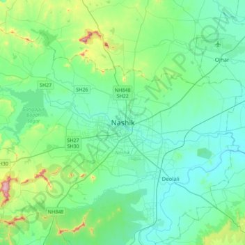
Name: Topografische Karte Nashik, Höhe, Relief.

Ort: Nashik, Nashik Subdistrict, Nashik District, Maharashtra, 422001, India (19.85125 73.63024 20.17125 73.95024)

Durchschnittliche Höhe: 631 m

Minimale Höhe: 535 m

Maximale Höhe: 1.079 m

Rüsten Sie sich für Ihr nächstes Abenteuer:

👕Funktionsshirt fürs Wandern - Atmungsaktives Shirt für Outdoor
📖Bücher: Orientierung im Gelände - Fachliteratur zu Navigation, Kompasskunde und GPS-Nutzung
🧢Outdoor Mütze - Leichte Mütze für kühle Temperaturen
🕶️Polarisiert Sonnenbrille - UV‑Schutz und klare Sicht bei Wanderungen
🧊Kühltaschen - Hält Proviant und Getränke bei Sommerhitze frisch

Als Amazon-Partner erhält diese Website eine Provision für qualifizierte Käufe, ohne zusätzliche Kosten für Sie.